


h6yXcrd2zCo

Jovila
User
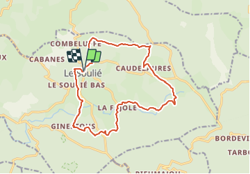

Length
17 km

Max alt
993 m

Uphill gradient
385 m
Km-Effort
22 km

Min alt
855 m

Downhill gradient
388 m
Boucle
Yes
Creation date :
2021-10-16 17:26:43.938
Updated on :
2021-10-16 17:26:43.938
--
Difficulty : Unknown

FREE GPS app for hiking
 SityTrail
IGN / Geographical institutes
SityTrail Plus
The world is yours!
About
Trail Walking of 17 km to be discovered at Occitania, Hérault, Le Soulié. This trail is proposed by Jovila.
Points of interest


Positioning
Country:
France
Region :
Occitania
Department/Province :
Hérault
Municipality :
Le Soulié
Location:
Unknown
Start:(Dec)
Start:(UTM)
474946 ; 4822093 (31T) N.
Comments